
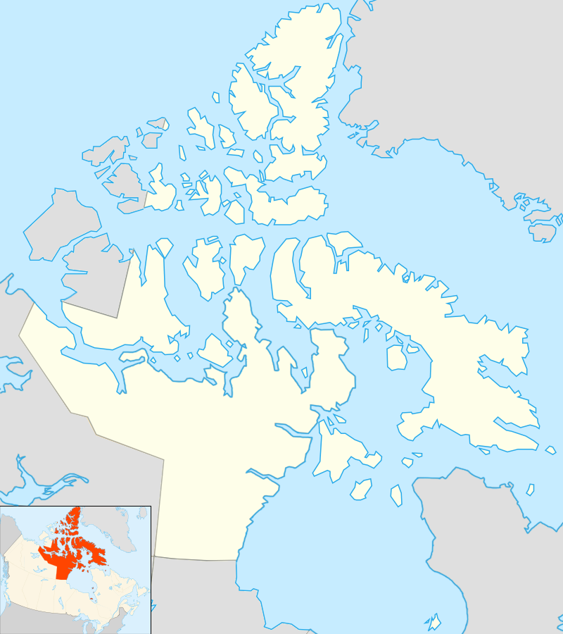
The Arctic
Where your Covictory Garden would freeze.
 |
| By Algkalv and Dr. Blofeld based on original by Yug. Inset map is by EOZyo. https://commons.wikimedia.org/w/index.php?curid=11418087 |
The waterways between these islands are claimed by Canada as internal waters but are viewed as international waters by other nations including the USA. There are also areas contested by other nations, such as Hans Island, and Ellesmere island which Denmark also claims as part of their territory. The question of sovereignty and ownership, what is internal waterways and what is international waters are at the focus of disputes.
The Northwest Passage is a growing concern for Canada as a result of climate change, as ice shifts and melts opening the waterways of the Arctic. If the area becomes more accessible to shipping, Canada and the inhabitants of this region are concerned for the sensitive environment.
Much of the people living in this region are members of First Nation, Métis or Inuit peoples, constituting 53% of the population. The territories of Nunavut, North West Territories and the Yukon have the greatest proportion of FNMI inhabitants in all of Canada. Exploration and mapping of this area has a long and bitter cold history, with new discoveries leading to maps being updated or entirely rewritten. You can check out some historic maps of Northern Canada through the McMaster University Maps digital archive. Charting the Northern Canadian North comes with many tragic and triumphant outcomes, from John Franklin to Ernie Weeks.
 |
| Ernie Weeks 1941 / Hamilton Spectator / Courtesy of The Canadian Warplane Heritage Museum Archives Collection |
Waterdown has some close connections to the mapping of our northern nation. Frederick Ernest "Ernie" Weeks, best known to most of us from "Weeks" - Home Hardware on Hamilton Street in town, was a member of the Royal Canadian Air Force during the Second World War. In 1940 Week's was summoned to Mount Hope airport (now John C. Munro Hamilton Airport next to Canadian Warplane Heritage) to be an instructor for the new B.C.A.T.P. - British Commonwealth Air Training Plan. As an R.C.A.F. pilot, Ernie was called upon to fly a secret mission aimed to map the north. In the process he left his mark in several places, naming Week's Lake in Shefferville, Quebec, Ernie's Lake in Nunavut, and a lake in his first wife Pauline's name.
In 1943 the mission to help map the Arctic and establish Canadian sovereignty in response to the Soviet's landing a four-engine aircraft in the Arctic in 1938. Ernie attended a secret meeting in Ottawa to be briefed on the mission objective.
"The government wanted more information on the Arctic. There were no maps of the area. RCAF aircraft didn't have the range to fly very far north, so bush pilots again were recruited. It was top secret. Our mail would go to a post office box in New York and then (be) transferred up to us."
Ernie Weeks The Spectator 2004.Weeks flew a Noorduyn Norseman to remote areas of the north where he would drop off a surveyor and supplies. The surveyor would build stone cairns with bronze markers that would serve as permanent fixes for aerial photography. The complete mapping of Canada's Arctic territory was completed in 1958.
Side note: The Canadian Warplane Heritage Museum has in it's aircraft collection an air-worthy Noorduyn Norseman. I first got to fly in it in August 2017, and have made a number of trips up in it.
 |
| Norseman Pre-Flight Fueling |
 |
| C-47 Environment Canada Markings |
 |
| C-47 Wartime Camouflage |
After the Second World War, the new likely foe to be fought were the Communists, the Reds, the Soviet Union. Fears circulated of attacks on The United States and Canada, and the path the bombers or rockets would take was determined to be over the North Pole and Arctic regions of Northern Canada. With what started in 1943, the initiative to map the northern region was deemed essential. Flying in the Arctic was difficult due to adverse weather conditions, unreliable magnetic compasses and the lack of accurate mapping. In order to protect the Capitalist West, the north had to be known. It was not only the RCAF that took on this initiative. The USAAF was up in the cold with us too, conducting transport of supplies to northern airbases under Operation Polaris. What the Americans didn't tell the Canadian government, was that they were also taking aerial reconnaissance photographs. Fearing that the Americans were searching for undiscovered islands they could claim for their own, thus undermining Canadian territorial sovereignty in the North. Diplomatic objections were filed, the Americans admitted "our bad," and agreed to stop.
 |
| Consolidated 'Canso' with B25 Mitchell in backgound 408 'Goose' Squadron Dept. National Defence / Library and Archives Canada / PA-067766 |
 |
| (Left) Fairchild K-20 Aircraft Camera next to Olympus Digital camera (Right) Believe it or not, the laptop is not an artifact (Yet). |
| Airwoman displaying types of aerial cameras used by the Royal Canadian Air Force in Operation Eclipse to photograph a solar eclipse. R.C.A.F. Station Rockcliffe, Ontario, Canada, 19 July 1945. Library and Archives Canada |
Using what they had learned from wartime photography, new technologies and methods were explored by the men and women at Rockcliffe.
The RCAF’s 1947 photographic flying season was impressive. Two squadrons conducted aerial surveys. One, equipped with Dakota aircraft and the latest navigational aids, completed 111,043 square miles of vertical photography. The other squadron, flying Lancasters and Mitchells, covered 293,000 square miles with trimetegron photography.
They were assisted by SHORAN (Short Range Aid to Navigation) which had grown out of wartime bombing technology. Portable SHORAN sites were established at increasingly remote sites. They emitted radar pulses that enabled personnel to establish precise distances between various points and thus draw the flight lines. Millions of photographs were forwarded to the RCAF’s Photo Establishment at Rockcliffe where they were assembled into mosaics which eventually became maps.
In 1948 while flying over the Foxe Basin off the southern coast of Baffin Island led to the discovery of two uncharted islands which added an additional 5000 sq miles of new territory to Canada!
| Preliminary indexing of tri-metrogon aerial photographs, No.1 Photographic Establishment, R.C.A.F., Rockcliffe, Ontario, Canada, 1 March 1945. Library and Archives Canada |
Eventually Avro Lancasters from No. 408 Squadron of Rockcliffe would take complete control of Arctic aerial mapping, and by 1951 had photographed the majority of the region. Attention at this time turned to aerial patrol of the Arctic region, and collecting atmospheric samples after Soviet nuclear tests.
Today, satellites and Google Earth make maps and viewing far off places seem simple, even mundane. But these developments had to start somewhere, and it was with the ingenuity and adventurous spirit of the men and women, some of them local - of the R.C.A.F.
Whew, this was a big post. I hope you read some of it at least. Saturday - gone.
Sources for this post:
Canadian Warplane Heritage Museum Archives Collection
Digital Archive Maps - McMaster University
Remembering Ernie - Flamborough Review
Passages: Bush pilot and Waterdown businessman 'a hard act to follow' - Toronto.com
Canadian Warplane Heritage Museum Aircraft Collection
A bird whose wings touched history - The Spectator
Aerial Visuals - Airframe Dossier - Douglas C-47
Dakota FZ692 - RAF Air Station Blakehill Farm, Cricklade UK
Digital Collection Photographs - Library and Archives Canada
Mapping the Canadian North - Post WWII - Alberta Aviation Museum, Edmonton
Mapping in Full Flight: Air Force, Part 28 - Legion
No comments:
Post a Comment